
Did Zvulun’s Tribal Portion Reach the Mediterranean Sea
Quote from A Solution to Fundamental Problems Regarding Tekhelet
Although there is an opinion that holds that the Tribal portion of Zvulun did not reach the Mediterranean Sea, we hold like the Vilna Gaon’s viewpoint to the book of Yehoshua {Joshua} 19:14 “that we have to say that the border of Zvulun cuts through the middle of Asher’s boundary, and goes to Tzidon Rabba {Greater Sidon} and there it expands a bit in its width like the shape of a thigh“.
According to the Book of Yechezkel the tribe of Zvulun in the future will get a different area as a tribal inheritance than what was received in the past.
The tribe of Zvulun as well as a few other tribes will receive in the future a portion in the Sinai Desert. Seemingly the tribe of Zvulun will once again be able to complain that to other tribes You gave fields and vineyards but now, they will not even receive compensation of having the Chilazon near their shores, since dye producing mollusks do not appear to be found in the southern Sinai region.
According to the book Ohr Yechezkel, if you accept a 47 cm. sized cubit, the future division of the land of Israel looks like the map below. In my article The Future Borders of the Tribes of Israel as Evidence for the Size of a Cubit I provided alternative views and maps. See there for details.
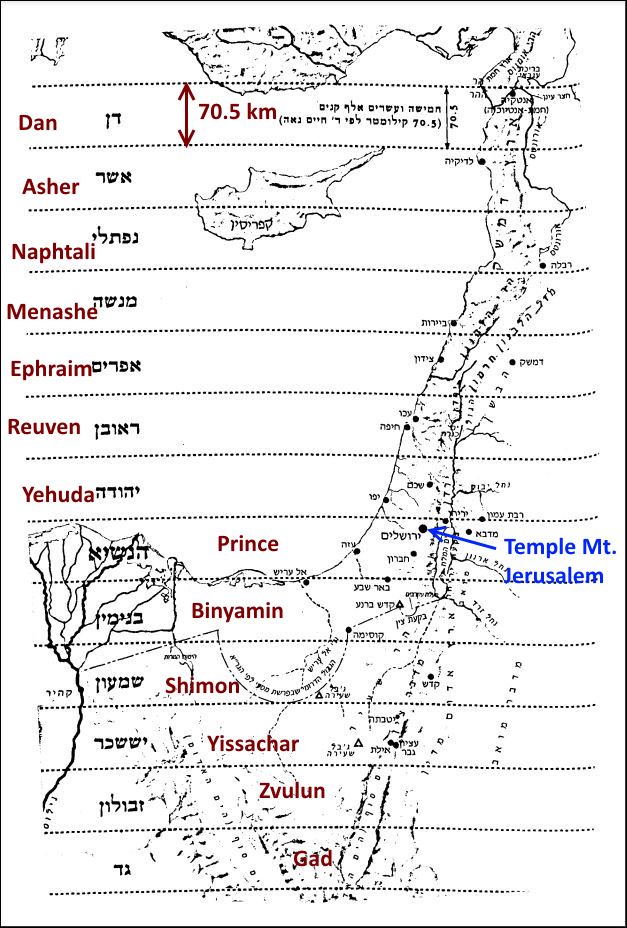 According to Sifri, Devarim, Parshat Haazinu, Piska 315 the Land of Israel in the Future Will be Divided into 13 Strips of 150,000 Cubits, Which is Equivalent to 75 Talmudic Mil
In the article The Future Borders of the Tribes of Israel as Evidence for the Size of a Cubit I point out that by assigning different values to a cubit you could either include more parts of the Sinai or less than what appears in the map above. But all the major Biblical maps based on the last two chapters of Yechezkel (Ezekiel) agree that some of the tribes of Israel will receive their future portion in the land of Israel in the Sinai region which is currently a desert.
Is it fair to assign the Sinai region which is currently mostly a desert to the southern tribes including Zvulun while the northern tribes seem to be getting a more fertile region?
My general answer is that Zvulun and the other southern tribes will be compensated by other benefits, but not necessarily the Chilazon of Tekhelet.
On a more specific level, I would like to suggest that the compensation might be in accordance to a Youtube video at youtube.com/watch?v=lBRUFbR-S2M that I asked Gemini AI to summarize.
Video Title: Israel Built a Hidden Fish System Beneath the Desert — And It Actually Worked
This summary explores how Israel transformed a barren desert into a thriving agricultural hub by turning environmental “problems” into a high-tech, sustainable goldmine.
## The Discovery: An Ocean Beneath the Dust
In 1973, geologists drilling in the Negev Desert (which covers 60% of Israel) struck the Nubian Aquifer. They found a massive reservoir of “fossil water” trapped since the last Ice Age. However, the water was initially considered worthless for two reasons:
- Boiling Temperature: It emerged at 99°F to 104°F due to geothermal heat.
- High Salinity: It was brackish (salty), containing 3,000 ppm of salt—enough to kill standard crops like tomatoes or wheat within days.
## The Innovation: Tropical Fish in the Desert
Instead of abandoning the wells, scientists asked: “What thrives in hot, salty water?” The answer was tropical fish like Barramundi, Tilapia, and Sea Bass.
- Free Heating: In Europe, farmers spend a fortune heating tanks for tropical fish. In the Negev, the Earth provides the perfect temperature for free, even when desert nights drop to 41°F.
- Healthy Environment: The salt content mimics the natural brackish habitats of these fish, keeping them healthier than in freshwater ponds.
- Massive Scale: Today, farms like Kibbutz Mashabé Sadé produce over 3,000 tons of fish annually, exporting them to major European supermarkets.
## The “Double-Usage” System: Turning Waste into Food
The biggest challenge in fish farming is ammonia (fish waste), which is toxic to the fish. Israel solved this by creating a symbiotic closed-loop system:
- Step 1: High-pressure water is pumped from 2,300 ft deep into fish ponds.
- Step 2: As fish grow, they saturate the water with nitrogen-rich waste (natural fertilizer).
- Step 3: This “dirty” water is piped directly to groves of Olive trees and Date palms.
- Step 4: These specific trees are salt-tolerant. They filter the ammonia out of the water to use as food, while the slight salt stress actually makes the fruit sweeter and more flavorful.
## Why It’s a Game Changer
- Economics
Fresh water in Israel is expensive ($0.70 per 35 cubic feet). Brackish water is nearly free ($0.05–$0.10). By sharing the water, the fish farm gets a free “disposal system” for waste, and the crop farm gets free water and free organic fertilizer.
- Environmental Impact
The system is carbon negative. It avoids the massive CO2 emissions caused by:
- Manufacturing synthetic fertilizers.
- Pumping and transporting fresh water.
- Heating fish tanks with fossil fuels.
- Additionally, the trees sequester (trap) thousands of pounds of carbon annually.
## The Bottom Line
The Negev project proves that constraints are opportunities. By pairing “useless” hot water with tropical fish and “toxic” waste with salt-tolerant trees, Israel created a food production system that is cheaper, cleaner, and more productive than traditional farming. This model is now being piloted in other arid regions like Egypt and Saudi Arabia.
“Impossible is just another word for nobody’s tried the right combination.”
A comparison table between traditional fish farming and this Negev desert system to highlight the cost and energy savings
Here is a breakdown of how the Negev desert system compares to traditional aquaculture and farming methods. This table highlights why the “Double-Usage” approach is such a massive leap forward in efficiency and sustainability.
Comparison: Traditional vs. Negev Desert System
| Feature | Traditional Fish Farming | Negev “Double-Usage” System |
| Water Source | Costly fresh water or coastal seawater. | Deep “fossil” water (90% cheaper). |
| Heating Costs | High (uses gas/electricity) to keep tropical fish alive in winter. | $0 (Geothermal energy keeps water at 100°F naturally). |
| Waste Management | Expensive filtration systems or dumping toxic waste into the ocean. | $0 (Waste is automatically sent to nourish crops). |
| Fertilizer Source | Synthetic nitrogen (high carbon footprint and expensive). | Free (Fish waste provides organic nitrogen). |
| Environmental Impact | High CO2 emissions; risks of algae blooms in oceans. | Carbon Negative; trees trap CO2 and no waste enters the wild. |
| Crop Quality | Standard growth. | Enhanced (Slight salt stress increases fruit sugar and flavor). |
Key Takeaway
In the traditional model, waste is a liability that costs money to remove. In the Negev model, waste is an asset that powers a second industry. This synergy allows desert-grown fish and fruit to be priced more competitively than those produced in “easier” climates.
The section above covers the Nubian Aquifer in the Negev. To be thorough I asked Gemini AI: Does the Nubian Aquifer run beneath the Sinai Desert?
Answer:
Yes, the Nubian Sandstone formation extends under the Sinai Peninsula, though whether it is considered part of the main Nubian Sandstone Aquifer System (NSAS) depends on how hydrogeologists strictly define the boundaries.
Key Details & Characteristics
1. Regional Hydrogeology
-
The Main NSAS Boundary: The formal “Nubian Sandstone Aquifer System” covers over 2 million km2 across Egypt, Libya, Sudan, and Chad. Geologically, its continuous main basin lies predominantly west of the Nile in Egypt’s Western Desert.
-
The Sinai Extension: The same Lower Cretaceous and Paleozoic sandstone formations (the Nubian Sandstone series) extend east across the Gulf of Suez and lie beneath central and northern Sinai. In regional hydrogeology, the deep, deep-seated water-bearing sandstone layers beneath Sinai are commonly referred to as the Nubian Sandstone Aquifer of Sinai or the Deep Nubian Aquifer.
2. Water Type & Depth
-
Fossil Water: Like the main Saharan NSAS, the deep water trapped within the Nubian sandstone under Sinai is largely fossil groundwater. It was recharged tens of thousands to hundreds of thousands of years ago during prehistoric wet (pluvial) climate periods.
-
Depth & Quality: In Sinai, the Nubian aquifer sits at significant depths—often 1,000 to over 3,000 meters underground. The water is typically confined under high pressure (artesian in some places). While fresh-to-brackish in parts, salinity generally increases toward the northern and coastal reaches of the peninsula.
3. Separation from Main Saharan Basin
Hydrogeologists often analyze Sinai’s Nubian aquifer separately from the Western Desert NSAS because:
-
Structural Barriers: The Suez Rift Valley / Gulf of Suez and associated faulting geographically and hydrologically separate the Sinai block from the main Western Desert basin.
-
Local Recharge: While the deep sandstone contains non-renewable fossil water, shallow upper layers in central/northern Sinai receive minor modern recharge from flash floods along major drainage networks (such as Wadi El-Arish), mixing localized fresh water with older deeper brackish reserves.
What can be answered if it ends up that the Nubian aquifer, doesn’t reach Zvulun territory or can’t be used there for some other reason?
Answer: I will fall back on my general answer, Hashem will then find some other way to compensate.
Article by Shlomo Moshe Scheinman